
Charts
In this section are presented differents nautical Mercator charts in scales:
Plans in scale 1:500 - 1:10,000 are provide guidance for ships in ports, harbors, bays, on raids, etc.
Charts in scale 1:10 000 - 1:75 000 are designed to ensure the safety of navigation in areas with difficult navigation and hydrographic, in narrow areas in the archipelago, in close proximity to the coast, etc.
Maps inscale 1:100 000 - 1:500 000 are used to provide navigation between ports in sight and out of sight of the coast and coastal landmarks. However, due to the large scale, they depict only the most significant hazards and objects, so this type of card is not recommended for coastal navigation.
Choose appropriate type and navigation area charts you can by cartograms or by using the left menu.
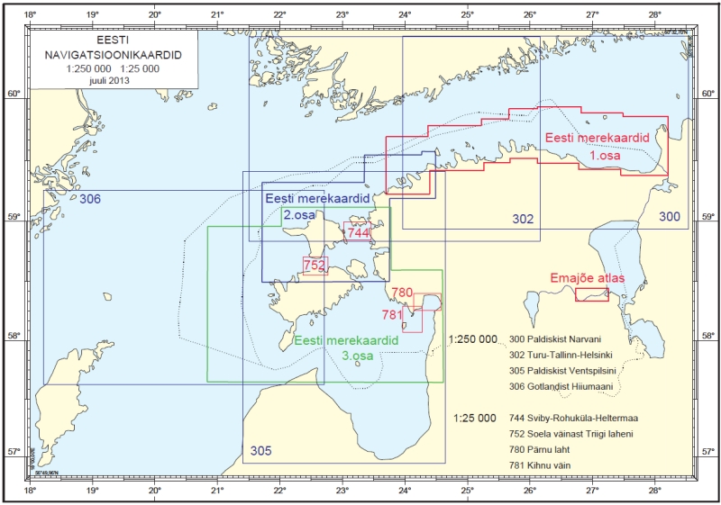
Maps in scale 1:250 000
- NamePriceSelect
Chart nr. 300
Route: From Paldiski to NarvaISBN: 978-9949-403-66-020 €Chart nr. 302
Route: From Turku - Tallinn - HelsinkiISBN: 978-9949-403-81-320 €Chart nr. 305
Route: From Paldiski to VentspilsISBN: 978-9949-403-55-420 €Chart nr. 306
Route: From Gotland to Hiiumaa IslandISBN: 9949-403-13-820 €
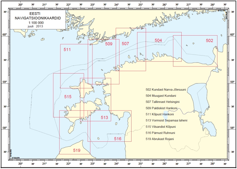
Maps in scale 1:100 000
- NamePriceSelect
Chart nr. 502
Route: From Kunda to Narva-JõesuuISBN: 9985-9216-8-220 €Chart nr. 504
Route: From Muuga to KundaISBN: 978-9949-403-64-620 €Chart nr. 507
Route: From Tallinn to HelsinkiISBN: 978-9949-403-71-420 €Chart nr. 509
Route: From Paldiski to HankoISBN: 978-9949-403-5920 €Chart nr. 511
Route: From Peninsula Kõpu to HankoISBN: 9985-9216-6-620 €Chart nr. 513
Route: From Vormsi Island to Sepamaa BayISBN: 978-9949-403-78-320 €Chart nr. 515
Route: From Island Vilsandi to Peninsula KõpuISBN: 9949-403-02-220 €Chart nr. 516
Route: From Port of Pärnu to Island RuhnuISBN: 978-9949-403-79-020 €Chart nr. 519
Route: From Abruka Island to Roja PortISBN: 9949-403-08-120 €
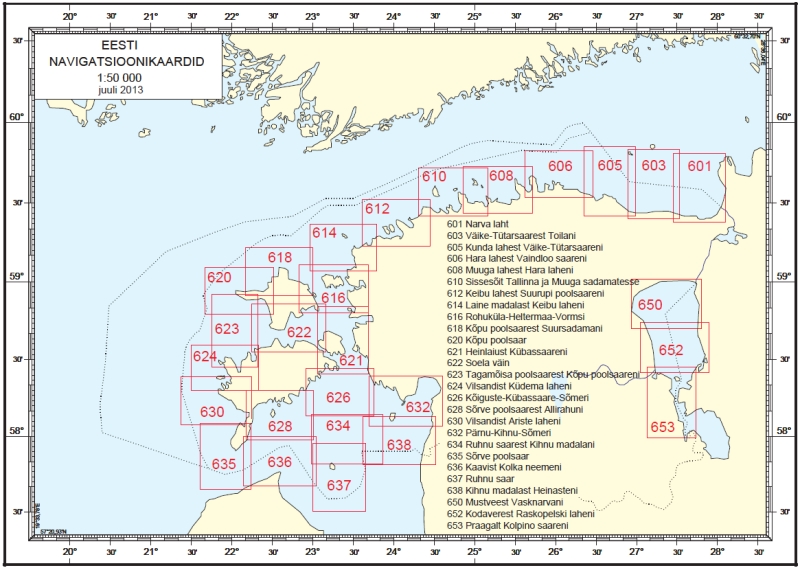
Maps in scale 1:50 000
- NamePriceSelect
Chart nr. 601
Route: Narva BayISBN: 978-9949-403-51-620 €Chart nr. 603
Route: From Malyy-Tyuters Island to ToilaISBN: 978-9949-403-56-120 €Chart nr. 605
Route: From Kunda Bay to Malyy-Tyuters IslandISBN: 978-9949-103-56-120 €Chart nr. 606
Route: From Bay of Hara to Islet VaindlooISBN: 9985-9216-2-320 €Chart nr. 608
Route: From Muuga Bay to Hara BayISBN: 9985-9155-7-720 €Chart nr. 610
Route: Approaches to ports of Tallinn and MuugaISBN: 978-9949-403-70-720 €Chart nr. 612
Route: From Keibu Bay to Suurupi PeninsulaISBN: 978-9949-403-54-720 €Chart nr. 614
Route: From Laine Shoal to Keibu BayISBN: 9985-9281-0-520 €Chart nr. 616
Route: Rohuküla-Heltermaa-VormsiISBN: 9949-403-07-320 €Chart nr. 618
Route: From Peninsula Kõpu to Harbour SuursadamISBN: 9985-9216-9-020 €Chart nr. 620
Route: Kõpu PeninsulaISBN: 9985-9331-9-220 €Chart nr. 621
Route: From Heinlaid Islet to Kübassaare PeninsulaISBN: 9949-403-04-920 €Chart nr. 622
Route: Soela StraitISBN: 9985-9331-0-920 €Chart nr. 623
Route: From Tagamõisa Peninsula to Kõpu PeninsulaISBN: 9985-9381-6-X20 €Chart nr. 624
Route: From Vilsandi Island to Küdema BayISBN: 9985-9381-5-120 €Chart nr. 626
Route: Kõiguste - Kübassaare - SõmeriISBN: 9985-9281-9-920 €Chart nr. 628
Route: From Sõrve Peninsula to Allirahu IsletISBN: 9985-9381-0-020 €Chart nr. 630
Route: From Vilsandi Island to Ariste BayISBN: 9985-9381-7-820 €Chart nr. 632
Route: Pärnu - Kihnu - SõmeriISBN: 978-9949-403-72-120 €Chart nr. 634
Route: From Ruhnu Island to Kihnu ShoalISBN: 9985-9331-3-320 €Chart nr. 635
Route: Sõrve PeninsulaISBN: 9985-9381-4-320 €Chart nr. 636
Route: From Kaavi to Kolka CapeISBN: 9949-403-00-620 €Chart nr. 637
Route: Island RuhnuISBN: 9985-9281-0-520 €Chart nr. 638
Route: From Kihnu Shoal to Heinaste (Ainaži)ISBN: 9985-9381-8-620 €Chart nr. 650
Route: From Mustvee to VasknarvaISBN: 9949-403-25-120 €Chart nr. 652
Route: From Kodavere to Raskopelski BayISBN: 9949-403-22-720 €Chart nr. 653
Route: From Praaga to Kolpino IslandISBN: 9949-403-11-120 €
Maps in scale 1:25 000
- NamePriceSelect
Chart nr. 733
Route: Tarvastu Polder to PikasillaISBN: 978-9949-403-91-220 €Chart nr. 744
Route: Sviby-Rohuküla-HeltermaaISBN: 9949-403-03-020 €Chart nr. 752
Route: From Soela Strait to Triigi BayISBN: 9985-9291-4-820 €Chart nr. 780
Route: Pärnu BayISBN: 9985-9331-2-520 €Chart nr. 781
Route: Kihnu StraitISBN: 9985-9281-5-620 €
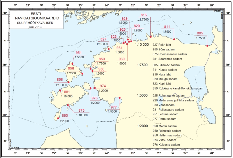
Maps in scale 1:10 000
- NamePriceSelect
Chart nr. 827
Route: Pakri BayISBN: 978-9949-403-58-520 €Chart nr. 856
Route: Harbour SõruISBN: 9985-9281-3-X20 €Chart nr. 875
Route: Roomassaare HarbourISBN: 9949-403-32-420 €Chart nr. 881
Route: Saaremaa HarbourISBN: 9949-403-35-920 €
Maps in scale 1:7 500
- NamePriceSelect
Chart nr. 805
Route: Sillamäe HarbourISBN: 978-9949-403-50-920 €Chart nr. 811
Route: Kunda HarbourISBN: 978-9949-403-49-320 €Chart nr. 816
Route: Hara BayISBN: 9949-403-42-120 €Chart nr. 820
Route: Muuga HarbourISBN: 978-9949-403-83-720 €Chart nr. 823
Route: Kopli BayISBN: 978-9949-403-77-620 €Chart nr. 850
Route: Rukkirahu Channel-Rohuküla HarbourISBN: 9985-9281-6-420 €
Maps in scale 1:5 000
- NamePriceSelect
Chart nr. 925
Route: Rohuneeme HarbourISBN: 9949-403-21-920 €Chart nr. 929
Route: Miiduranna and Pirita HarboursISBN: 9949-403-10-320 €Chart nr. 930
Route: Vanasadam HarbourISBN: 978-9949-403-82-020 €Chart nr. 931
Route: Paljassaare HarbourISBN: 9949-403-12-X20 €Chart nr. 951
Route: Lehtma HarbourISBN: 9949-40-23-520 €Chart nr. 977
Route: Pärnu HarbourISBN: 978-9949-403-68-420 €
Maps in scale 1:2 000
- NamePriceSelect
Chart nr. 890
Route: Mõntu HarbourISBN: 978-9949-403-62-220 €Chart nr. 950
Route: Rohuküla HarbourISBN: 978-9949-403-78-820 €Chart nr. 956
Route: Heltermaa HarbourISBN: 978-9949-403-74-520 €Chart nr. 974
Route: Virtsu Harbour and Virtsu Vanasadam HarbourISBN: 978-9949-403-75-220 €Chart nr. 976
Route: Kuivastu HarbourISBN: 978-9949-403-76-920 €
Share: